|
MacGillycuddy's
Reeks and Nearby Irish Mountains
GPS Coordinates, Route Data, and Photographs
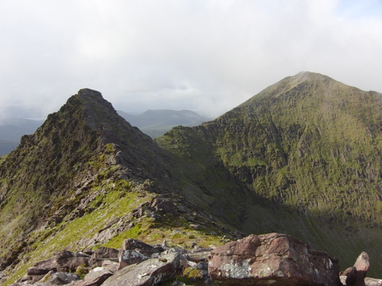
The
Big Gun and Knocknapeasta viewed from the summit of Cruach Mhór on July
3, 2010
We
hiked ten of the Irish Munros in July 2010, nine of them in one
day. I have created this site to share some information about
our experience and to provide data that may be useful to
others.
There
are 14 Munros in Ireland, i.e. mountains over 3,000 feet.
This count may vary slightly, depending upon whether you include some
of
the connecting ridges and twin peaks. The Irish Munros are largely
situated in southwest Ireland, mainly in MacGillycuddy's Reeks near
Killarney National Park. Many can be hiked in a single
day.
Disclaimer:
hiking/climbing/hill walking in the Irish Munros can be
dangerous. Necessary precautions should be taken to prevent
accidents. People HAVE died in these mountains and many more
have
become stranded (see
here, for example). The owner of this site takes no
responsibility
for the safety or accuracy of this information, which is intended
solely as a reference. You should use common sense and
consult the Kerry
Mountain Rescue site for more information on how to hike
responsibly.
Contents
On this site you will find the following:
1. A list of ALL of the
Munros in Ireland
2. Route data
and GPS
coordinates for our hike in MacGillycuddy's
Reeks
3. Some additional GPS
coordinates and data for summits near the Reeks,
as well as data for Brandon Mountain, another Irish Munro located in
Southwest Ireland
4. Our gear list
5. Photos of our
hikes in Ireland
6.
Additional
Resources
All Irish Munros
Formatted version available here
1.
Carrauntoohil (Corrán
Tuathail) - MacGillycuddy's Reeks
2.
Beenkeragh (Binn Chaorach) -
MacGillycuddy's Reeks
3. Caher
(East Top) -
MacGillycuddy's Reeks
4.
Knocknapeasta (Cnoc na
Péiste) - MacGillycuddy's Reeks
5. Caher
(West Top) -
MacGillycuddy's Reeks
6. Maolán
Bui -
MacGillycuddy's Reeks
7.
Carrauntoohil Tooth (The Bones)
- MacGillycuddy's Reeks
8. Cnoc an
Chuillin -
MacGillycuddy's Reeks
9. Brandon
Mountain (Sliabh
Bhreandáin) - Brandon Group
10. The Big Gun - MacGillycuddy's Reeks
11. Cruach Mhór - MacGillycuddy's Reeks
12. Cnoc an Chuillin East Top (L.Coimín Móir
Mountain) - MacGillycuddy's Reeks
13. Lugnaquillia - Dublin/Wicklow
14. Galtymore - Galty Mountains
Table of all
Irish Munros
|
No.
|
Name
|
Mt. Range
|
Height
(Meters)
|
Height
(Feet)
|
Notes
|
|
1
|
Carrauntoohil (Corrán
Tuathail)
|
MacGillycuddy's Reeks
|
1039
|
3409
|
Latitude: 51.999447
Longitude: -9.742744
ITM: 480336 584480
|
|
2
|
Beenkeragh (Binn
Chaorach)
|
MacGillycuddy's Reeks
|
1010
|
3314
|
Latitude: 52.006808
Longitude: -9.746452
ITM: 480101 585305
|
|
3
|
Caher (East Top)
|
MacGillycuddy's Reeks
|
1001
|
3284
|
Latitude: 51.994466
Longitude: -9.758581
ITM: 479235 583952
|
|
4
|
Knocknapeasta (Cnoc na
Péiste)
|
MacGillycuddy's Reeks
|
988
|
3241
|
Latitude: 51.997923
Longitude: -9.695682
ITM: 483563 584234
|
|
5
|
Caher (West Top)
|
MacGillycuddy's Reeks
|
975
|
3199
|
Latitude: 51.995450
Longitude: -9.762492
ITM: 478969 584068
|
|
6
|
Maolán Bui
|
MacGillycuddy's Reeks
|
973
|
3192
|
Top of the "Bone"
Latitude: 51.994619
Longitude: -9.701104
ITM: 483182 583875
|
|
7
|
Carrauntoohil Tooth
|
MacGillycuddy's Reeks
|
959
|
3146
|
Middle of Beenkeragh
/Carrauntoohil ridge
|
|
8
|
Cnoc an Chuillin
|
MacGillycuddy's Reeks
|
958
|
3143
|
Latitude: 51.990142
Longitude: -9.713542
ITM: 482316 583397
|
|
9
|
Brandon
Mountain (Sliabh Bhreandáin)
|
Brandon Group
|
952
|
3123
|
Latitude: 52.235188
Longitude: -10.254350
ITM: 446025 611667
|
|
10
|
The Big Gun
|
MacGillycuddy's Reeks
|
939
|
3081
|
Middle of Cruach Mhor
/Cnoc na Peiste ridge
Latitude: 52.000970
Longitude: -9.688807
ITM: 484043 584562
|
|
11
|
Cruach Mhór
|
MacGillycuddy's Reeks
|
932
|
3058
|
Latitude: 52.003847
Longitude: -9.688784
ITM: 484052 584882
|
|
12
|
Cnoc an Chuillin East Top
(L.Coimín
Móir Mountain )
|
MacGillycuddy's Reeks
|
926
|
|
About 600 mtrs East of
Cnoc an Chuillin
|
|
13
|
Lugnaquillia
|
Dublin/Wicklow
|
925
|
3035
|
Latitude: 52.966859
Longitude: -6.464494
ITM: 703146 691780
|
|
14
|
Galtymore
|
Galty Mountains
|
919
|
3015
|
Latitude: 52.366037
Longitude: -8.179118
ITM: 587801 623844
|
MacGillycuddy's
Reeks Route Data
Formatted pdf version available here
Our approach took approximately 12 hours and
included 9 of
the Irish Munros, in addition to several lesser summits. A
longer
hike with a detour to Caher's twin peaks could theoretically take in
all 11 of those Munros
which are located in the Reeks.
Our route began at Cronin's Yard (see here)
and included the following peaks in the horseshoe-shaped Reeks ridge,
followed by a return hike to Cronin's Yard:
-
Cruach
Mhór
-
The Big
Gun
-
Knocknapeasta
(Cnoc na Péiste)
-
Maolán Bui
-
Cnoc an
Chuillin East Top
-
Cnoc an
Chuillin
-
Cnoc na
Toinne
-
Carrauntoohil
(Corrán Tuathail)
-
The Bones
(aka Carrauntoohil Tooth or the Beenkeragh Ridge)
-
Beenkeragh
(Binn Chaorach)
-
Knockbrinnea
(W)
-
Knockbrinnea
(E)
Table with
additional data (all GPS
data was tested and found to be accurate in July 2010):
|
Name
|
Height
(Meters)
|
Height
(Feet)
|
Summit
Rank
|
Coordinates
|
Notes
|
|
Cruach Mhór
|
932
|
3058
|
11
|
Latitude: 52.003847 Longitude:
-9.688784
ITM: 484052 584882
|
From Cronin's Yard pass through a gate at
the
top right side of the car park. Follow
a
grass track along the side of a field and onto a stony track that
climbs gently above the Gladdagh River. Leave the track where it
crosses a tributary of the Gladdagh and head southeast across open
ground, climbing toward the summit of Cruach Mhór. Aim to the east of the
summit for easier
ground.
1.5-2 hours from Cronin's yard to the summit
of Cruach Mhór.
|
|
The Big Gun
|
939
|
3081
|
10
|
Latitude: 52.000970 Longitude: -9.688807
ITM: 484043 584562
|
*Challenging*
Middle of Cruach Mhor /Cnoc na Peiste ridge.
This peak is at the south end of the arête connecting it to
Cruach Mhór. The Big Gun Ridge (runs north-south) is
directly south of Cruach Mhór and it is a narrow
arête that should not be attempted by those who do not have the
head for it. Follow informal paths below and to the west of
the
ridge being careful not to lose too much height. Around one
hour
from Cruach Mhór to Knocknapeasta.
|
|
Knocknapeasta (Cnoc na Péiste)
|
988
|
3241
|
4
|
Latitude: 51.997923 Longitude:
-9.695682
ITM: 483563 584234
|
The lake below this peak is Loch
Coimín
Piast. In December
1943 an American Dakota
aircraft crashed into the slopes of Cnoc na Péiste just above
the lake. Pieces of the aircraft are still visible. A plaque here
commemorates the 5 victims and there is another plaque at Cronin's Yard. Look for the wing of a
plane in the corrie
lake below. From
here, the ridge walk from
Knocknapeasta à
Maolán Bui à
Cnoc an Chuillin à Cnoc na Toinne
is relatively flat
Travel about 1.25 hours to get from Knocknapeasta
to Cnoc an Chuillin
|
|
Maolán Bui
|
973
|
3192
|
6
|
Latitude: 51.994619 Longitude: -9.701104
ITM: 483182 583875
|
Sometimes called Bearna Rua. The nearby
ridge
known as "the Bone" (not to be confused with "The Bones") descends NW
from this peak. This
is a good escape route off the eastern Reeks (p.
90 Ryan).
|
|
Cnoc an Chuillin East Top
|
926
|
3038
|
12
|
Latitude: 51.991092 Longitude: -9.706911
ITM: 482774 583492
|
Located mid-way between Cnoc an Chuillinn
itself and Maolán Buí. Previously L Coimín
Móir Mtn in MV.
|
|
Cnoc an Chuillin
|
958
|
3143
|
8
|
Latitude: 51.990142 Longitude:
-9.713542
ITM: 482316 583397
|
|
|
Cnoc na Toinne
|
845
|
2772
|
23
|
Latitude: 51.990429 Longitude: -9.731402
ITM: 481091 583458
|
Between Cnoc an
Chuillin and the Devil's Ladder there should be an escape
route
(BEFORE reaching the Devil's Ladder) that provides a simpler descent
than the Ladder directly into Hag's Glen
|
|
The Devil's Ladder
(between Cnoc na Toinne and Carrauntoohil)
|
N/A
|
N/A
|
N/A
|
|
From Cnoc na Toinne swing
to the
northwest and drop down to the top of the Devil's ladder (the
Ladder is a reasonable escape
route if needed). From
the top
of the Devil's Ladder to the summit of Carrauntoohil is a long
trudge over stony paths. All
paths lead to
summit
|
|
Carrauntoohil (Corrán Tuathail)
|
1039
|
3409
|
1
|
Latitude: 51.999447 Longitude:
-9.742744
ITM: 480336 584480
|
Highest mountain in Ireland. Between Devil's
Ladder and Beenkeragh.
- To the SOUTH of the cross is the way you
came
- To the NORTH of the cross is a
cliff marked
by skull & crossbones à
steep drop!
- Beenkeragh is due north but you must FIRST
descend to the west-northwest to pick up the path
|
|
The
Bones
(aka Carrauntoohil Tooth)
(aka the Beenkeragh Ridge)
|
959
|
3146
|
7
|
Latitude: 52.001721 Longitude: -9.747041
ITM: 480047 584740
|
*Challenging*
A rocky
arête between Carrauntoohil and Beenkeragh.
This
narrow ridge running between Beenkeragh and Carrauntoohil is
well-defined but challenging. The
most
dangerous section is the area of the Ridge closest to Carrauntoohil.
|
|
Beenkeragh (Binn Chaorach)
|
1010
|
3314
|
2
|
Latitude: 52.006808 Longitude:
-9.746452
ITM: 480101 585305
|
Beenkeragh offers challenging scrambling on
the Hag's Tooth Ridge. It
is connected to
Carrauntoohil by a ridge known as the Bones. Beenkeragh is
the
second highest mountain in Ireland.
|
|
Knockbrinnea (W)
|
854
|
2801
|
16
|
Latitude: 52.012095 Longitude: -9.737161
ITM: 480753 585878
|
From Beenkeragh make a long, steep descent
northeast over Knockbrinnea. Knockbrinnea is a shoulder of Beenkeragh
overlooking the Hag's Glen. The walk from Beenkeragh to Knockbrinnea
follows a well-defined path.
|
|
Knockbrinnea (E)
|
847
|
2778
|
22
|
Latitude: 52.011428 Longitude: -9.733640
ITM: 480993 585798
|
Knockbrinnea is a shoulder of Beenkeragh
overlooking the Hag's Glen.
There is a safe descent from Knockbrinnea
back
to Cronin's Yard
|
Other
Summits
Formatted pdf version available here
|
Name
|
Height
(Meters)
|
Height
(Feet)
|
Summit
Rank
|
Coordinates
|
Notes
|
|
Caher (East Top)
|
1001
|
3284
|
3
|
Latitude: 51.994466 Longitude:
-9.758581
ITM: 479235 583952
|
Southwest of Carrauntoohil
|
|
Caher (West Top)
|
975
|
3199
|
5
|
Latitude: 51.995450 Longitude:
-9.762492
ITM: 478969 584068
|
Southwest of Carrauntoohil
|
|
Cnoc an Bhráca
|
731
|
2398
|
87
|
Latitude: 52.009693 Longitude: -9.663254
ITM: 485820 585492
|
Well east of Cruach Mhór.
On reaching Cnoc an Bhráca when
traversing the
eastern Reeks, Cruach Mhór , the Big Gun and the ridge between
come into full view.
|
|
Cnoc Iochtair
|
747
|
2450
|
78
|
Latitude: 52.013010 Longitude: -9.770509
ITM: 478466 586035
|
Well west of Beenkeragh.
The
first peak on the northern side of Coomloughra.
|
|
Cnoc na dTarbh
|
655
|
2148
|
179
|
Latitude: 52.005838 Longitude: -9.657446
ITM: 486209 585054
|
Well east of Cruach Mhór.
It is the second most easterly summit in
the
MacGillycuddy's Reeks area.
|
|
Skregmore
|
848
|
2782
|
21
|
Latitude: 52.013706 Longitude: -9.760034
ITM: 479187 586095
|
Northwest of Beenkeragh
|
|
Stumpa Bharr na hAbhann
|
851
|
2791
|
18
|
Latitude: 52.012199 Longitude: -9.753814
ITM: 479610 585917
|
Northwest of Beenkeragh
|
|
Hag's Tooth
|
650
|
2132
|
193
|
52.005267 Longitude: -9.734552
ITM: 480914 585114
|
The rock is remarkably unstable on the
western
slopes and boulders can tumble down unexpectedly. Also known as
Stumpeenadaff, from Ir. Stuimpín an Daimh [OSNB], 'little
pinnacle of the ox'. Previously Stoompeenaduff in MV.
|
|
Name
|
Height
(Meters)
|
Height
(Feet)
|
Summit
Rank
|
Coordinates
|
Notes
|
|
Brandon Mtn
(Sliabh Bhreandáin)
|
952
|
3123
|
9
|
Latitude: 52.235188 Longitude:
-10.254350
ITM: 446025 611667
|
Located on the
Dingle Peninsula in
Southwest Ireland
|
Gear
List
This gear list kept us well-equipped for our hike in the Reeks in early
July 2010.
Temps ranged from low 50's to upper 60's. Warmer gear would obviously
be required in cooler weather
-
Backpack
~ 35 L / 2100 cu in capacity
-
Water
reservoir: 3 liter (100 oz) capacity, filled
-
Enough
food for one meal plus several snacks
-
Waterproof
rain jacket with hood
-
Waterproof
rain pants
-
Hiking
socks
-
Hiking
boots
-
Hiking
pants (convertible)
-
Tech
t-shirt
-
Long
sleeve tech t-shirt
-
Fleece
-
Knit hat
-
Cap
-
Mittens
-
Sunglasses
-
Camera
+ extra batteries and media
-
GPS
device + two sets of extra batteries
-
Compass
-
Cell
phone fully charged
-
Sunblock
-
Insect
repellant
-
Ziplock
baggies and/or dry sac(s)
-
Binoculars
-
Emergency
whistles
-
Ultralight
emergency medical kit
-
Headlamp
and/or flashlight and spare batteries
-
Route
data
-
Topo
maps
Photographs
A
photo essay of our hikes with descriptive captions can be found here:
(under construction)
Additional Resources
These
sources are invaluable:
1.Hiking
in Ireland (Lonely Planet), Helen Fairbairn and Gareth
McCormack, 3d ed. (May 2010)
2.
Carrauntoohil & MacGillycuddy's Reeks: A
Walking Guide to Ireland's Highest Mountains, Jim Ryan (July
2007)
3.
Ridges of England, Wales and Ireland,
Dan Bailey (Sept 2009)
4.
Ordnance Survey Ireland MacGillycuddy's Reeks Weatherproof
Topo Map (1:25,000), 2d ed. (2005)
5.
Harvey Superwalker MacGillycuddy's
Reeks Weatherproof Topo Map (1:30,000)
6.
http://www.kerrymountainrescue.ie/
7.http://mountainviews.ie
© 2010 Jude Thomas All Rights
Reserved
|